Friends Lake is located in the heart of the Adirondacks. Read further down the page to learn about the history of Friends Lake and the surrounding area. Friends Lake and the surrounding area is rich in history predating colonization and the Civil War. For more detailed history and information visit Warren County History (we celebrated our bicentennial in 2013) and Town of Chester Brief History.
A high-resolution PDF map of the Adirondack Park is available here, showing in great detail, all of the state forest lands, mountains, and waters. A full list of the NYS Adirondack Park Agency’s maps are available online for viewing and download/
About Friends Lake
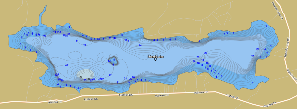
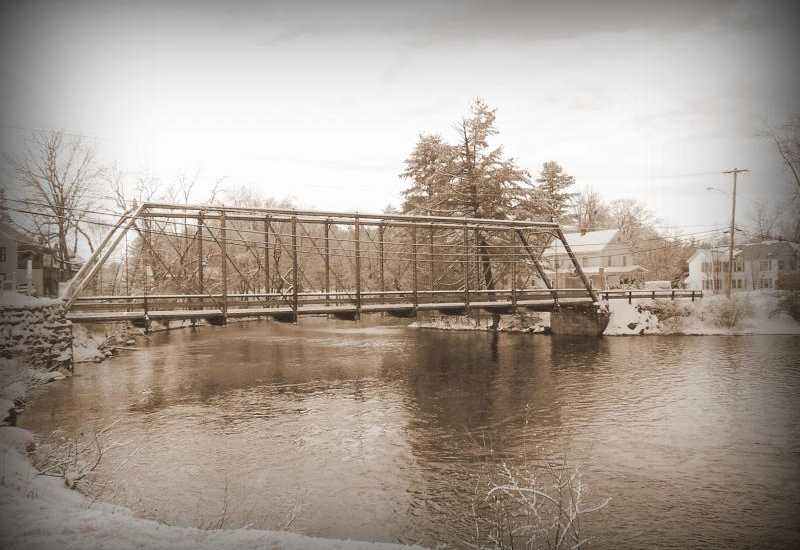
Friends Lake is a private 450-acre lake in New York’s Adirondack Park, south of Chestertown, New York. It has a mean depth of 14 feet, a maximum depth of 30 feet, and a shoreline length of 6.1 miles. This is a private lake. There is no public access, however, visitors may visit the lake at the Fern Lodge or Friends Lake Inn, nearby.
Friends Lake History
Written by H. Tennyson Baldwin, 1999
The Old Ways
The Adirondacks, which are located in upstate New York, were once a part of the great territory of the Iroquois and other Native Americans that lived in the North East. Evidence of Native Americans were formerly found on the James Murphy property at the north end of Friends Lake. Stone camp circles, remnants of the old campfires and other indications were originally present while subsequent cultivation over the years continued to turn up broken arrowheads, stone ax heads and knives and other artifacts about campsites. (Our daughter found a spearhead on our property when she was nine).
Before the Revolutionary War most of the people in the area were hunters and trappers, although a few settlers had established themselves and the area was surveyed in 1772. Following the Revolution, settlers began to come in larger numbers. Land was cleared and cultivated and self-sufficient communities began to appear.
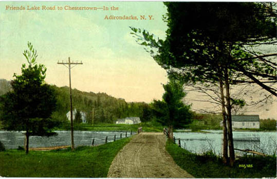
They grew their own food supplemented by fish and game, ground their own flour, corn meal and livestock feed, wove their own cloth, spun the wool they raised into yarn, and sawed the lumber they used. As soon as possible, machinery was imported to increase production of necessities, being packed in by horseback or transported by wagon over primitive roads hewed through the forest. The only power available to operate machinery was the waterpower of the streams flowing through the area. Development was rapid: sawmills, gristmills, wool carding mills and tanneries began to appear and during the period of small stream water power the outlet brook from Friends Lake had four mill sites between the lake and the junction of its waters with those to Loon Lake.
Revolutionary War Era
The person probably most deeply involved in promoting development in the area was one John Thurman. In 1778 he was granted a large tract of land in what are now the towns of Warrensburg, Thurman, and Johnsburg, for construction of a highway. In 1800 an additional grant was made to him that included the so-called South Gore of the town of Chester, in which the area around Friends Lake is located.
Warren County, where Friends Lake is located, was named for General Joseph Warren, a Revolutionary War hero. Joseph Warren was born in Roxbury MA in 1741. He was a leader in the repeal of the Stamp Act of 1765 and was active with the Sons of Liberty and with pro-American Masons and was involved in the famous events of Paul Revere, known for announcing the attack of the British. Joseph Warren was later buried in the Forest Hills Cemetery at Roxbury.
Post Revolutionary War
During the nineteenth century the main industries were farming, lumbering and leather production. The farms supplied the food for the inhabitants and hides for the tanneries, while the forests furnished the raw material for the lumbering industry and the oak and hemlock bark for the leather factories. Logs were sawed for local use, but the major portion of the annual production of the logs and pulpwood was piled along the banks of the Hudson River during the fall and winter and carried down stream on the during spring flood to the sawmills and paper mills at Fort Edward, Hudson Falls and Glens Falls.
The Civil War Era
The excellent fishing at Friends Lake greatly influenced the growth of the summer resort business. Until the Civil War the varieties of fish that originally populated its waters were still abundant. But just before or shortly after following that conflict, great northern pike and small-mouthed bass appeared. The result was an immediate decline in the native brook trout population and its disappearance before 1900. During the first decade of the twentieth century wall-eyed pike were planted and flourished. The origin of the large-mouthed bass, now in plentiful supply, is a mystery as no record of their introduction appears in the Conservation Department files.
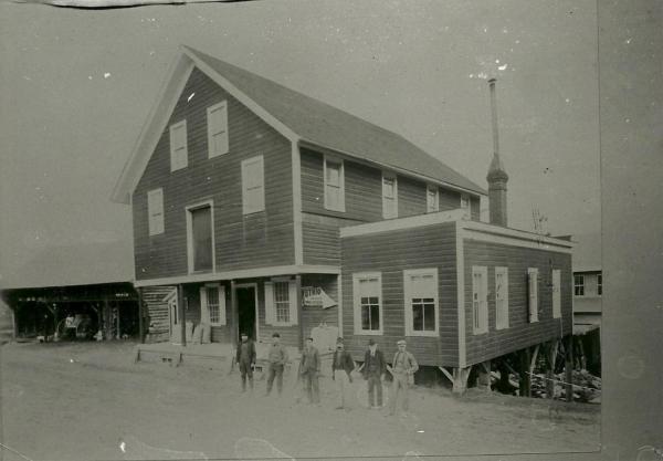
There is no record of a mill at the outlet of Friends Lake, but the first dam was built at the sand bar, several hundred feet above the present dam, at an early date. Its purpose was to convert the lake into a reservoir holding back the water from spring floods and heavy rains for later release as mills on the outlet stream below needed water. The water from Friends Lake powered a wool carding mill and gristmill at the Wilbur Tennyson property, a sawmill behind Frasier’s and a tannery behind the Perine residence. There was also a chair factory on the brook flowing from Sullivan’s Pond into Friends Lake. This was located a few hundred yards north of the buildings on what is locally known as the Stockfarm, on the Friends Lake-Darrowville road, and was operated by the Force family.
Towards the end of the nineteenth century a new business began to develop and expand and by 1900 had become well established as more and more city residents began spending their summer vacations in the Adirondacks. The summer hotel business reached its peak during the 1920s.
Modern Times
The development of more economical chemical processes for rapid production of leather eliminated the tannery industry and the demand for oak and hemlock bark. The opening of the vast farmlands of the Midwest following the Civil War signaled the beginning of the decline of farming in this area, although it continued to exist into the twentieth century. The invention of the spinning and knitting machinery made spinning wheels obsolete and closed the local wool carding mills. As people in this area moved from the farms into the villages and cities or migrated to more favorable farming areas, forest growth began encroaching upon the abandoned fields and pastures, reclaiming what had been wrested from it. The opening of the Panama Canal so reduced shipping rates from the fast forests of the Pacific Northwest that West Coast lumber could be sold in the areas less than the cost of producing native lumber. World War I postponed this effect, but the last logs were driven down the Hudson shortly after the end of that war, and the last of the mills on the outlet stream below Friends Lake, the sawmill located behind Frasier’s, ceased operations in the 1920’s.
With the abandonment of the mills using water from the Friends Lake reservoir, there was an end to an income to provide the maintenance of the Friends Lake dam. The high water of spring floods washed away the embankment; frost action tumbled rocks from the face wall; the heavy timbers and planning of the gate and its supporting structure gradually rotted until it collapsed and was carried away. When the need for the present dam was recognized nothing remained to prevent the water of the lake above the sandbar levels from escaping.
Friends Lake for Recreation
The first two dams were constructed and maintained to provide the necessary power for local industry during the era of small stream waterpower. The present dam was constructed and is being maintained to serve the needs of a different era, in which the local businesses and residents are dependent upon the use of Friends Lake waters almost entirely for recreation and enjoyment. he needs of the previous era produced a dam whose gate could be used to raise or lower the lake level at will, whereas the present day’s gateless dam’s purpose is to maintain, within limits, a uniform lake level. Today, Friends Lake and many of the other hundreds of lakes in the Adirondacks are used for people’s second homes and for recreation and enjoy to get away and relax in nature and the mountains.
About the Adirondack Park
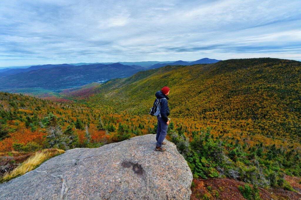
The Adirondack Region is one of the most diverse destinations on the East Coast, offering unparalleled outdoor recreation throughout its dazzling lakes, wild mountains, and charming towns and villages. Established in 1892 by the State of New York amid concerns for the water and timber resources of the region, the Adirondack Park today covers an area larger in size than Yosemite, Yellowstone, Glacier, Grand Canyon and the Great Smokies National Parks combined, and is the largest park in the lower 48 states.
Encompassing millions of acres of public, constitutionally protected forest preserve, as well as privately owned land, the Adirondack Park is New York’s largest playground. Striking a balance between public and private ownership makes the Adirondack Park a unique place to visit. Visitors have ample access to recreation gear through hotel amenities, rental shops, and local guide services. Park residents often enjoy the serene Adirondack experience alongside travelers and share their knowledge of the area.
Learn more about the park here.
Quick Facts About the Adirondacks
Size
- The Adirondack Park comprises about 6.1 million acres (9,375 square mi).
- The park is the size of the state of Vermont.
- There’s no marked boundary to the park, no “entrance gate” and no admission fee.
- The Adirondack Park is the largest protected area in the contiguous United States, delineated by the famous “blue line.”
- The Adirondack Park is larger than Yellowstone, Yosemite, Glacier, Grand Canyon and Great Smokies combined.
Geography & Features
- The Adirondack Park contains 85% of all wildernesses in the eastern United States. It is the largest wilderness area east of the Mississippi.
- The Adirondack Park has over 2,000 miles of hiking trails; these trails comprise the largest trail system in the nation.
- It is theorized that there is a geologic “hotspot” beneath the Adirondacks that causes continued uplift at the rate of 1.5 – 3 cm annually.
- The western and southern Adirondack area is a gentle landscape of hills, lakes, ponds and streams, along with the highest mountains in the state. The 46 High Peaks (over 4,000 feet) include Mount Marcy, the highest point in New York at 5,344′.
Water
- Within the park are 3,000 lakes and ponds and more than 1,200 miles of rivers fed by an estimated 30,000 miles of brooks and streams ideal for Adirondack canoeing.
- One of the park’s most unique features is the nonstop juxtaposition of mountains and water.
- Special regulations govern 1,200 miles of Adirondack river corridors, designated as part of the New York State Wild, Scenic, and Recreational River System.
- Essex County, located in the Adirondack Park, contains the greatest number of waterfalls in New York.
Ownership
- The New York State Legislature created the Adirondack Park in 1882 by enacting measures that guaranteed public lands would remain “forever wild” – the strongest such law in the United States.
- The Adirondack Park Agency was created in 1971 to encourage wise land use planning for the region.
- The park is a patchwork of public and private lands. Visually, very little difference exists between state owned and privately owned land
- State-owned Forest Preserve comprises 2.6 million acres (42%) and is protected by the state constitution as “forever wild.” One million acres of the Forest Preserve is further classified as wilderness.
- Approximately 3 million acres are privately held but sparsely populated.
- During the last 100 years, state purchase has increased the Forest Preserve from the original 680,000 acres to its present 2.6 million acres and still growing.
- The “blue line”, originally encompassing 2.6 million acres, now encircles nearly 6 million acres (roughly the size of Vermont).
People & the Park
- Approximately 137,000 people live in the Adirondacks twelve months of the year.
- The park is home to 200,000 seasonal residents. Hamilton County has the largest percentage of 2nd homeowners in the nation.
- There are over 100 villages and towns within the park but no cities. It is the largest area without a city in the state.
- An estimated 7-10 million tourists visit the region annually.
- 60 million people live within a days’ drive of the Adirondack region.
- Adirondack lodging consists of over 11,000 rental rooms in hotels, motels, inns and cottages, along with almost 12,000 campsites.
Recreation
- The Adirondacks offers some of the finest opportunities in the eastern United States for outdoor recreation in a superb natural setting, including boating of all kinds, camping, picnicking, hiking, mountaineering, cycling, hunting, fishing, swimming, downhill and cross-country skiing, ice skating and snow-shoeing.
- The word “vacation,” was invented in the Adirondacks. In the early 1900’s people in the cities were beginning to realize that summer heat and deadly fevers went hand in hand. The upper class did not spend the summer in the city waiting for a fever; they vacated the city for the fresh clean air of the Adirondacks. The term “vacating” or evacuating is the reason Americans take “vacations” instead of a British “holiday.”
- The Lake Champlain Birding Trail is ranked by Audubon Magazine as one of the nation’s top six destinations in the nation for bird watching.